Welcome to our photographic record of Burnley

We hope that older viewers will enjoy recalling past times and younger people will be interested in seeing parts of Burnley which have disappeared.


The captions to these photographs are from our personal recollections and we trust that they are accurate, although if any viewer can offer any correction or additional information this would be welcome.


If you have any comments send an email: oldburnley@gmail.com

Padiham Road

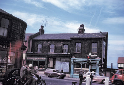
This is Padiham Road at its junction with Accrington Road, Trafalgar Street and Westgate, with John Watts clock visible in the background.  This part of Padiham Road is now known as Westway and the shops have been demolished.
Another view of this junction, showing the demolished shops.  The pharmacy business of J. A. Barlow stood at the junction of Padiham Road and Accrington Road and had a splendid display of glass jars, containing various coloured liquids.
This is Padiham Road at its junction with Barracks Road and Gannow Lane.  The car, which is partly hidden by the telephone box, is leaving Gannow Lane.  The area is now occupied by the roundabout at junction 10 of the M65.
The M65 involved substantial building work in Burnley and here we see some preparatory work, in what is now the Cavalry Way area, near junction 10.  On the right is St. Mary Magdalene's RC church, in the middle is Yatefield Mill on Cog Lane, and the row of houses on the left were on Scott’s Terrace, which survived until fairly recent times.  All the buildings have been demolished.
Another similar view and we can see the parapets of the new bridge over the Rose Grove to Colne railway line with the tower of St. John's C of E church to the right of St. Mary Magdalene's RC Church.
The Barracks Tavern, which we think was on Padiham Road and allegedly contained a museum.  The building no longer exists.  Further information regarding a museum here would be welcome.
These two photographs show Padiham Road, and not only have the buildings disappeared, but this part of Padiham Road has gone.  It was approximately at the top end of Pendle Way, near the junction 10 roundabout.
We think this is looking along Barracks Road, and the church spire in the background certainly belonged to Manchester Road Methodist Church.  The street name on the gable end is not decipherable, but may be Cornwall Terrace.
Barracks Road, where it is beginning to bend round to meet Gannow Lane and Padiham Road.  All the buildings have been demolished and this site is near Cavalry Way.